Sign up for the Family Tree Newsletter Plus, you’ll receive our 10 Essential Genealogy Research Forms PDF as a special thank you!
Get Your Free Genealogy Forms
"*" indicates required fields
I spent an embarrassing number of years searching Jackson County, Mo., records for my great-great-grandfather. After unsuccessfully poring through church memberships, cemetery inscriptions and census films, I did something I should have done long before: I pulled out my Missouri gazetteer and scrutinized the area surrounding the family farm in Lone Jack. There, plain to see, were the boundary lines of two other counties-both within spitting distance of the tiny town I’d spent years researching.
On my next trip to the library, I found Grandpa in less than an hour. In 1900, at the age of 77, he was living with a daughter less than 20 miles from Lone Jack, just over the line into Cass County.
After that experience I don’t do much research without my maps at hand-and neither should you, especially when even obscure maps are so easy to get your hands on these days. Besides, my ancestors were an itchy-footed bunch, so tracking their movement means tracing old roads and rivers. And that means using old maps.
Look at a map and you’ll understand migration routes and patterns. clearly, the easiest routes were along coasts or down rivers. (For a map of popular US migration, see the June 2001 Family Tree Magazine.) Pull out a present-day atlas and try to imagine it without roads. You’ll quickly see how your ancestors traveled, and why they ended up in certain locales. If you ever “lose” a generation, you can use maps to help speculate on your ancestors’ possible new home.
Since most birth, death and land records were kept at the county level, knowing the county your ancestor lived in is essential for tracking down those records. But finding the right locale isn’t always easy: Although your ancestor may have lived in the same location for generations, that place’s name and the county where it was located may have changed numerous times. Your search for the family who didn’t move may lead you to more county courthouses than tracing the ones who migrated every generation.
Fortunately, Map Guide to the U.S. Federal Censuses, 1790-1920 (Genealogical Publishing Co.) will help with the changing boundary problem. The book shows all US county boundaries. On each map, old county lines are superimposed over modem ones to highlight boundary changes at 10-year intervals. You can also find many excellent guides to changing county lines on the state pages of the USGenWeb site <www.usgenweb.org>.
Of course, old maps — which show former boundaries and place names — are also essential for tracking ancestral territory. To get a feel for your ancestors’ surroundings, a period map will probably help more than a visit. Thanks to modern engineering and Mother Nature, the topography of a place may have changed so much that your ancestor wouldn’t recognize his favorite fishing hole. Period maps depict the landscape as it was, including the rivers your family crossed and the forests they helped clear.
Where do you look for cartographic clues to your ancestors? You can find them right around the corner, or even from your own home. Hone in on these seven spots to locate historical maps and the genealogical treasures they contain:
1. Library of Congress Map Collections: 1500-1999
<memory.loc.gov/ammem/gmdhtml/gmdhome.html>
The Geography and Map Division of the Library of Congress has digitized a portion of its 4.5 million items and placed those images on the Web. You may not find a map of your ancestor’s property in this collection, but you will find a map he most likely knew during his own lifetime. The LOG created the online images from maps and atlases that aren’t under copyright protection, so you can even download them to illustrate your family history book.
The collection is divided into seven categories, and all contain potentially valuable images for your genealogy research. You can search the entire collection or each category individually:
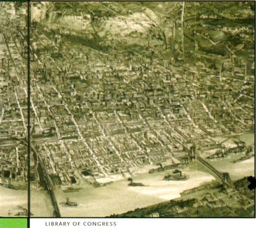
• Cities and Towns: This section features panoramic views of cities. Here I found an 1868 “bird’s eye view” of my hometown, Saint Joseph, Mo., in amazing detail. The panoramas are drawings of cities as if viewed from above. Although they’re not drawn to scale, they do show street patterns, buildings and landscape features in perspective.
Panoramic maps of towns are currently available in every state except Alaska and Hawaii. The collection also has maps from the Canadian provinces of British Columbia, Nova Scotia, Ontario and Quebec. Once you find a map of interest, you can zoom in or out on any section.
• Cultural Landscapes: This collection has large-scale (high-detail) topographic maps, land surveys and atlases, including several maps of Native American land. Here you’d find an 1849 image of a Shaker Village in Canterbury, NH, an 1887 Oklahoma Indian Territory map and a guide to the 1848 California gold fields, for example. My favorite image is from 1766: “A plan of my farm on Little Huntg. Creek & Potomk. R” drawn by “GW” — George Washington.
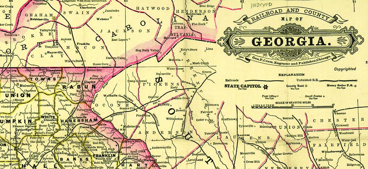
• Transportation and Communication: These maps will show how your ancestors traveled and the routes they took. Transportation maps depict canal and river systems, railway lines and roads. Communication maps show the location and distribution of telegraph routes. Railroad maps show you the route your train-traveling ancestors took; the ones here include progress report surveys for individual rail lines, route guides, government surveys and maps showing land grants and rights of way.
To locate railroad maps in a specific state, choose Geographic Location, then click on your state of interest. A typical map is “New enlarged scale railroad and county map of Tennessee showing every railroad station and post office in the state, 1888.” You can also search by keyword.
• General Maps: These maps show areas larger than towns or cities. For example, you’ll find “A new mapp of East and West New Jarsey” dating to 1706 or an 1867 image showing the Alaskan territory ceded by Russia to the United States.
This is the section to search if you want to visualize a bigger picture of your ancestors’ world. The maps often contain exceptional detail: For example, the 1751 map of the “most inhabited part of Virginia, containing the whole province of Maryland with part of Pennsylvania, New Jersey and North Carolina” shows not only rivers, but also many creeks and other small landscape features.
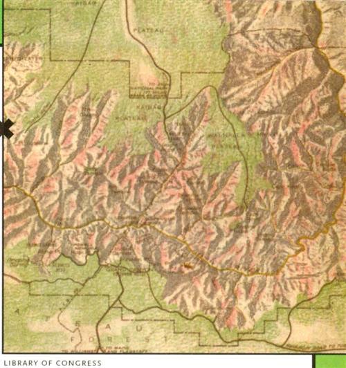
• Conservation and Environment: Although you might not think this type of map would be helpful in genealogy, conservation and environment maps are an excellent source for detailing changes in the landscape, including natural and man-made features, geology, wetlands and wildlife.
Want to see how things have changed over a hundred years? Look at the 26 maps of Yellowstone National Park, dating from 1871 to 1988 (under Geographic Locations, click United States — Wyoming — Yellowstone National Park). You’ll also find a 1904 image of Bar Harbor, Maine, that includes the names of property owners and the streets they lived on. Maps of specific conservation projects, such as the growth of the US National Parks, also fit in this category.
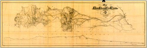
• Discovery and Exploration: A portion of these maps and manuscripts covers European explorations of America dating from the late 15th century. Here you’ll find detailed maps of coastlines and outlines of continents. The 18th-and 19th-century maps document exploration of interior parts of the continent, such as the maps of Lewis and Clark or later government explorers and surveyors.
If you have an ancestor who was an early traveler westward, don’t miss the hand-drawn maps of newly discovered territory. In particular, check out the Lewis and Clark map, with annotations in brown ink by Meriwether Lewis, showing the “Mississippi, the Missouri for a short distance above Kansas, Lakes Michigan, Superior, and Winnipeg, and the country onwards to the Pacific.”
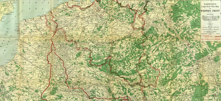
• Military Battles and Campaigns: Did Great-great-grandpa shoulder a rifle in the Civil War? You’ll want to download and print the campaign maps that show the battles in which he fought.
These maps include troop movements, defensive structures, roads, campsites and vegetation. Some maps were actually drawn on the battlefield. They can also provide genealogy clues, since some show the location of plantations, small towns, Native American settlements and names of landowners.
2. Local libraries
Your local library is a great starting point for hard-to-find historical atlases and maps. You’ll probably have to do your research on site, however, as most libraries keep older books in the reference section.
Collections vary from library to library — what you get depends on where you live. But these examples from my public library show the types of map-related resources you’re likely to come across:
• Historical Atlas of Expeditions by Karen Farrington (Checkmark Books)
• Philip’s Atlas of World History edited by Patrick O’Brien (George Philip Limited)
• The Routledge Historical Atlas of the American South by Andrew K. Frank (Routledge)
• The Routledge Historical Atlas of the American Railroads by John F. Stover (Routledge)
• The Historical Atlas of the American Revolution by Ian Barnes (Routledge)
Be sure to ask the reference librarian for help. All the library’s valuable historic holdings may not be evident to a casual browser — and some might be stored in another section of the library or at a separate facility. A local college or university library could also be a great source for historical maps of your area. (For more on using university libraries for family history research, see the April 2001 issue of Family Tree Magazine.)
3. Historical societies
A local historical society is frequently the repository for original maps and documents pertaining to a specific county. The Research Archives of the San Diego Historical Society, for example, owns an extensive map collection that documents San Diego’s past. It consists of more than 2,000 maps of San Diego County, the Southwest and Baja California. Its categories include 400 maps of city subdivisions and topographic quadrangles, more than 20,000 parcel (assessor’s) maps for 1957 to 1958 and a 20-volume aerial photo map collection. The society also has a set of Sanborn fire insurance atlases updated to 1955.
4. Fire insurance maps
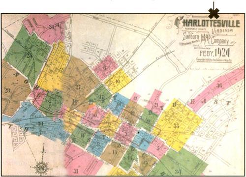
Fire insurance maps were originally produced to assess fire risks and insurance costs. The maps are extremely detailed, drawn to a scale of 50 feet per inch. Printed in color, they display information about streets, businesses, houses and utilities. You’ll find a brief history of the origin of fire insurance maps at <fisher.lib.virginia.edu/sanborn/about.html>, along with an actual Sanborn fire insurance map of 1920 Charlottesville, Va. <fisher.lib.virginia.edu/sanborn/igio/fullindexmap.htmb.>
Sanborn, founded in 1866, is one of the oldest mapping companies in the United States. Its maps show titles of businesses, names of owners, building materials and structural dimensions. Environmental Data Resources (EDR) owns the largest collection of Sanborn maps — more than 1.2 million covering 12,000 US towns and cities — and sells copies to the public. Costs vary. To order, visit EDR’s Web site <www.edrnet.com/reports/historical.html> or call (800) 352-0050.
5. Family History Centers
The map you need may be right around the corner at your local Family History Center. Unlike those at historical societies, however, the maps here aren’t limited to the local area. Holdings at my local FHC fill more than a dozen map drawers. Among them are maps of:
• Medieval England
• Central Belfast, 1931
• York County, Ont., 1860
• Montreal, 1953
• Philadelphia, 1860
• The Travels of George Washington
• Pennsylvania, 1796
• Rowan County, NC, 1808
• Southwest Virginia, including Wilderness Road, Boone’s Road
• New Jersey, 1778
Because many of the items were donated by library patrons, the selection will vary widely from center to center. You can find the center nearest you at <www.familysearch.org/Eng/Library/FHC/frameset_fhc.asp>.
6. National Archives and Records Administration List of Selected Maps of States and Territories
<www.nara.gov/publications/leaflets/sl29/sl29home.html>
NARA’s Web site catalogs 900 state maps (including maps of US territories) from the holdings of the Special Media Archives Services Division. The maps date from the late 18th century to 1920.
Click on the name of a state in the left column to see the maps available in this collection. Copies of the maps are not online — if you want a copy you need to order one. My search led me to an 1827 map of Missouri, Illinois and the Territory of Arkansas. It has two 30×41 -inch sections, with a scale of 1 inch to 12 miles. The map shows township and range numbers, settlements, roads, forts, canals, Indian villages, lead mines and iron works. It also gives descriptions of military bounty lands.
To order maps, you must first send a request to carto@arch2.nara.gov, write to Special Media Archives Services Division — Cartographic (NWCS), National Archives and Records Administration, 8601 Adelphi Road, College Park, MD 20740 or fax your request to (301) 713-7488 (follow detailed instructions on the Web site). NARA will then mail you a list of vendors who will copy the map for you.
7. United States Geological Survey Geographic Names Information System
GNIS is the official database for place names. It’s maintained by the US Geological Survey and is an excellent resource if you know a place name but aren’t sure where it’s located.
The database’s 2 million entries encompass the names of places that no longer exist as well as secondary names for existing places. This is an excellent place to search for old cemeteries and churches. But you can also search for dozens more geographic features, from streams to bridges to post offices. Click on US States and Territories (or go directly to <geonames.usgs.gov/gnisform.html>) to access the search form. The database retrieves potential matches; each results page tells the feature type, state, county, variant names and the latitude and longitude coordinates for the location. Click on Show Feature Location to see it on a US and a local map. You can also view digitized topographic maps and aerial photographs from TerraServer <terraserverhomeadvisor.msn.com>.
The GNIS results page will also give the name of the printed USGS map that contains the feature you searched for. You can order these maps (nearly 70,000 in a variety of scales) directly from the USGS.
We’ve all used the scales on a road map to estimate driving distances. A scale is the relationship between the distance on the map and the distance on the ground. For example, if a scale is 1:63,360, it means that 1 inch on the map equals 63,360 inches on the ground (one mile). The larger the second number, the smaller the scale of the map. Small-scale maps cover more ground, but show less detail. Large-scale maps (1:600, for example) cover a smaller space in detail.
The most common USGS map scale is 1:24,000. These maps are commonly known as 7.5-minute quadrangle maps because they cover 7.5 minutes of latitude and 7.5 minutes of longitude (there are 60 minutes in a degree). They’ll usually include campgrounds, important buildings, bridges, fence lines and private roads.
Look for an online list of available USGS maps at <mac.usgs.gov/mac/maplists/>, as well as a large list of Fact Sheets. Fact Sheets <mac.usgs.gov/mac/isb/pubs/pubslists/> discuss subjects such as finding historical maps
and using maps in genealogy. You can read them online or download them in Adobe Acrobat (PDF) format. If you don’t have Web access, call the AskUSGS fax-on-demand system at (888) 275-8747. Follow the prompts to request an index of all available documents. The six-page index lists the document number to request. The index will also tell you how many pages any document contains. For example, there are 15 pages of Georgia maps, but only two pages listing Hawaii maps. Once you decide which lists you want, just call back the fax-on-demand number and follow the prompts to have the documents sent to your fax machine.
ADVERTISEMENT