Sign up for the Family Tree Newsletter Plus, you’ll receive our 10 Essential Genealogy Research Forms PDF as a special thank you!
Get Your Free Genealogy Forms
"*" indicates required fields
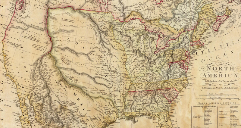
In 1803, Napoleon Bonaparte had grand ambitions to conquer Europe. But to do so, he needed cash. To help fund his war effort, Napoleon decided to sell France’s North American territories. France colonized the area west of the Mississippi in the mid-1600s, but lost the land (called the Louisiana territory) to Spain after the Seven Years’ War. Napoleon negotiated with Spain to reacquire the Louisiana territory in 1800, then sold the 828,000 square miles to the United States. US President Thomas Jefferson got quite the deal—just $15 million for all that land. This Louisiana purchase map, created in 1804, shows just how much US boundaries expanded thanks to that fateful deal.
The Louisiana Purchase (bounded roughly by the Mississippi River in the east and the Continental Divide in the west) doubled the United States’ size. With all this newly acquired land, Americans were eager to explore this new frontier. The purchase included all of modern Arkansas, Iowa, Kansas, Missouri, Nebraska and Oklahoma, as well as portions of nine other states:
- Colorado: Area east of the Continental Divide
- Louisiana: Northern and eastern sections, including New Orleans
- Minnesota: Central and southern sections
- Montana: Area east of the Continental Divide
- New Mexico: Northeast corner
- North Dakota: Western and southern sections
- South Dakota: All but the northeastern tip
- Texas: Northern sections along the Oklahoma border
- Wyoming: Area east of the Continental Divide
If you have Canadian ancestry, you might notice the Louisiana Purchase also included parts of Alberta and Saskatchewan. The United States gave these strips of land to Great Britain in the Treaty of 1818 in exchange for the rest of modern Minnesota, North Dakota and South Dakota.
The map allocates a different color to each state or territory, allowing you to distinguish between American, Spanish and British lands. Notice much of the western United States is still under Spanish control, and that the map indicates which American Indian tribes were prominent in each region.
The map also treats the Eastern United States in an interesting way. Though made in 1804, the map doesn’t feature the newly admitted state of Ohio. Rather, the land is still considered part of the Western Territory. Likewise, the relatively new Kentucky (admitted 1792) and Tennessee (admitted 1796) aren’t indicated as their own states. Their coloration suggests they’re still parts of Virginia and North Carolina, respectively.
This map can provide valuable context as you chart your ancestors’ migrations across the United States. Were your ancestors pioneers braving a new frontier? Or did they stay in the relative safety of Eastern cities?
For more interesting maps of the United States, check out The Family Tree Historical Maps Book. Inside, you’ll find hundreds of beautiful, full-color historical maps, plus useful information about US history.
Last updated, April 2018.
ADVERTISEMENT