Sign up for the Family Tree Newsletter Plus, you’ll receive our 10 Essential Genealogy Research Forms PDF as a special thank you!
Get Your Free Genealogy Forms
"*" indicates required fields
Immigration to the United States reached its peak between 1880 and 1920, as scores of people from Germany, Ireland, Eastern Europe and elsewhere flocked to make homes in the “land of opportunity.”
In fact, in the decades from 1870 to 1900, nearly 12 million immigrants fled famine, persecution, crop failures and economic hardship to what they hoped would be the American Dream. By the 1880s, three-quarters of immigrant arrivals in the United States passed through the “golden door” of New York, whether at Ellis Island (which opened in 1892) or its predecessor, Castle Garden.
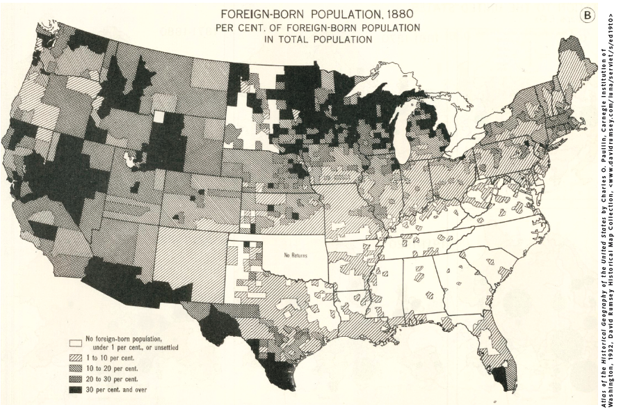
Other major ports of immigration included Boston, Philadelphia, Baltimore, New Orleans and San Francisco. Many immigrants remained in or near these port cities, often settling near their countrymen in densely populated neighborhoods. But as this map shows, once in the United States, immigrants also fanned out from the coasts to scatter across the country. Employers in need of workers and many states, especially those with relatively scant populations and plentiful land, attempted to attract immigrants with advertisements boasting numerous jobs or land for farming.
This 1932 map, from the Carnegie Institute of Washington’s Atlas of the Historical Geography of the United States, is based on 1880 census information. In Oklahoma (then Indian Territory, where native tribes had been relocated), data from that census are missing for non-Indians as well as many Indian tribes.
From the January/February 2015 Family Tree Magazine
ADVERTISEMENT