Long before the New England Patriots dominated the NFL, Boston established itself as one of the most important American cities. Colonists famously dumped hundreds of chests of tea into Boston Harbor, and tensions between British and Colonial forces finally bubbled over a few years later with the “shot heard ’round the world” in the nearby Battles of Lexington and Concord. By 1790, “Beantown” had the third-largest population in the United States, behind only New York City and Philadelphia. How else can we learn about Boston’s history? This detailed historical map of Boston can help.
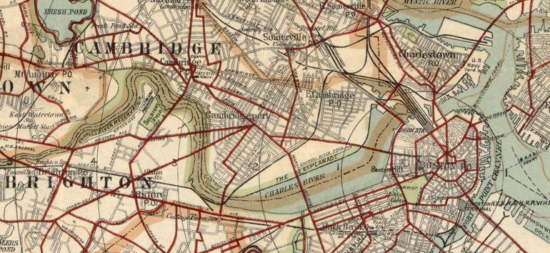
Created in 1905 and held by the Library of Congress, this map displays the Greater Boston area. In addition to Boston proper, you’ll see Cambridge, Salem and other boroughs and towns in northeastern Massachusetts. The key, which you can find by accessing the full map online, has lines of varying color, thickness and texture. Each represents a different road or boundary, with the red line tracing (of all things) bicycling routes around the region. The map even indicates two different shades of green for parks: solid green for existing parks, and green stripes for planned parks. The circles around the city’s center represent mile markers from the post office in downtown Boston.
The map skimps on street names, but its scale can prove useful for those whose ancestors lived in the outskirts of Boston or in neighboring cities. You can also use the map alongside census records or city directories like those available at the Boston Public Library. In addition, knowing what country and city your ancestor lived in can aid you in finding vital records. By comparing this to earlier and later historical maps of Boston, you can also trace the city’s growth. (The city annexed Hyde Park in 1914, reaching its modern boundaries.)
You can learn more about Boston genealogy by using our detailed city guide. Find more great maps of America’s largest cities (including Boston, New York, Philadelphia and more) in The Family Tree Historical Atlas of American Cities.
Author