As the United States grew, made treaties with Indians and awarded land bounties for Revolutionary War and War of 1812 service, settlers migrated from the original states to the Old Southwest (Alabama and Mississippi), the Old Northwest (Ohio, Indiana, Illinois, Michigan, Wisconsin and northeastern Minnesota), Kentucky and Tennessee.
Racial oppression and rumors of the reinstitution of slavery led many freedmen to leave the South. In 1879 and 1880, African-American migrants to Kansas—where blacks bought more than 20,000 acres of land after Reconstruction—became known as Exodusters.
By 1940, severe dust storms had caused 2.5 million people to flee the Plains states; 200,000 of them to California. Author John Steinbeck immortalized the plight of these migrants—who came to be called “Okies”—in The Grapes of Wrath.
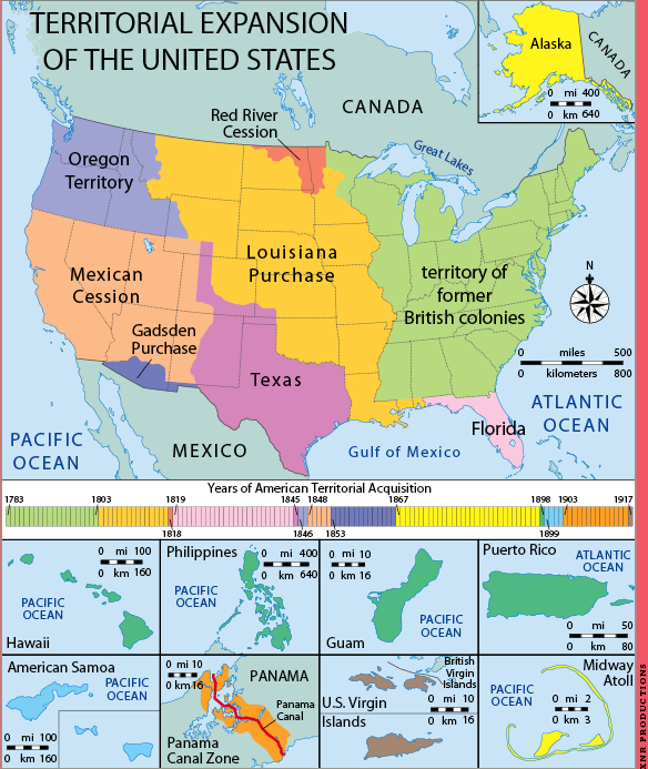
1803 Louisiana Purchase (828,800 square miles in what’s now Arkansas; Missouri; Iowa; Oklahoma; Kansas; Nebraska; part of Minnesota; most of North Dakota and South Dakota; northeastern New Mexico; parts of Montana, Wyoming, and Colorado; and Louisiana)
1819 Florida
1845 Texas
1846 Oregon Territory
1848 Mexican Cession (California, Nevada and Utah, plus parts of Colorado, New Mexico, Arizona and Wyoming)
1867 Alaska, Midway Islands
1898 Hawaiian Islands, Philippine Islands, Guam, Puerto Rico
1899 American Samoa
1903 Panama Canal Zone
Braddock’s Road
This route connected Cumberland, Md., on the Potomac River to the Monongahela River south of present-day Pittsburgh. In 1813, construction began on the Cumberland Road (later called the National Road), which followed much the same route.
Mohawk Trail
By 1770, this trail reached from Albany to Buffalo. The Catskill Turnpike overlapped it after the Revolutionary War. In 1825, the Erie Canal provided a waterway from Albany to Lake Erie.
Pennsylvania Road
Incorporating the Great Conestoga Road and then later, Lancaster Pike, the Pennsylvania Road connected Philadelphia to Pittsburgh at the head of the Ohio River. Much of the route west of Harrisburg followed the early path of Forbes Road, blazed during the French and Indian War.
SOUTH
Carolina Road
An alternative to the Fall Line Road, the Carolina Road (also called the Upper Road) tracked through Hillsboro and Charlotte, NC, in the 1750s. It originally extended to Greenville, SC, but in 1828 connected to the Federal Road at Athens, Ga.
Fall Line Road
Beginning in about 1735, travelers would leave King’s Highway at Fredericksburg, Va., and head southwest to Augusta, Ga., at the head of the Savannah River. Eventually, many Alabama- and Mississippi-bound pioneers would follow the Fall Line Road to link up with the new Federal Road in Columbus, Ga.
Federal Road
In 1806, Congress appropriated $6,400 for this road to carry mail between Athens, Ga., and New Orleans. It was widened and partly rerouted in 1811, connecting Fort Stoddert, Ala. (north of Mobile), to Fort Wilkinson, Ga., on the Chattahoochee River, where the route merged with the original postal path.
Great Valley Road
Known to Indians as the Great Warrior Path, this trail’s forerunner reached from New York to present-day Salisbury, NC, where it connected with the Great Trading Path.
Its feeders included the Philadelphia Wagon Road, which in the 1740s linked up with the Pioneer’s Road from Alexandria, Va., and went on to Winchester, Va. The Great Valley Road also became a feeder into the Wilderness Road.
King’s Highway
Incorporating the Boston Post Road between Boston and New York, King’s Highway could be called America’s first interstate. It eventually stretched 1,300 miles south from Boston through most of the Colonies’ important cities, to Charleston, SC.
Natchez Trace
The first major north-south route in the South, the Natchez Trace followed Indian trails from Nashville, Tenn., to Natchez, Miss., on the Mississippi River. The 500-mile route was upgraded in 1806, and briefly supplanted by the Jackson Military Road, which reached New Orleans in 1820.
OLD NORTHWEST
Chicago Road
This road from Detroit to Chicago, built between 1829 and 1836, brought pioneers to southern Michigan and Illinois.
National Road
Originally the Cumberland Road, the route was called the National Road by 1825 because of its Congressional funding. Construction of the 600-mile span, which eventually stretched from Cumberland, Md. (incorporating the old Braddock’s Road), to Vandalia, Ill., began in 1811.
State Road
Connecting to the Chicago Road, the State Road extended west from Chicago through Elgin and Rockford to Galena, Ill., on the Mississippi River.
Zane’s Trace
In 1796 and 1797, Col. Ebenezer Zane built this road through Ohio between Wheeling, WV, and Maysville, Ky. The segment between Wheeling and Zanesville, Ohio, also called the Wheeling Road, was ultimately upgraded and incorporated into the National Road.
APPALACHIAN WEST
Richmond Road
Many settlers bound for Kentucky traveled this route through Virginia from Richmond to Fort Chiswell, where it joined the Great Valley Road.
Wilderness Road
Daniel Boone led six families through the Cumberland Gap into Kentucky in 1775, pathfinding what was originally called Boone’s Trace. It would become known as the Wilderness Road when it was widened in 1796.
Tennessee-bound settlers took the Knoxville Road south from Kentucky to the Nashville Road, or the Nickajack Trail from Fort Loudon (now in Tennessee) to the Chickasaw Trail (later renamed Robert’s Road).
WEST
California Trail
Blazed in 1841, this trail split off from the Oregon Trail at Soda Springs, Idaho, after Fort Bridger. It followed the Bear River and crossed the Great Salt Lake Desert and Sierra Nevada mountains. California Gold Rush migrants tried other routes: Some went north of the Great Salt Lake and through a corner of Idaho to rejoin the trail at the Humboldt River. From Nevada, the Lassen Route aimed north of Sutter’s Mill, while the southerly Carson Route headed southwest.
Mormon Trail
Mormon leader Brigham Young set off with his followers from Nauvoo, Ill., in 1846. They crossed Iowa and the Missouri River to the site of present-day Florence, Neb., then traced the north bank of the Platte River from Fort Kearny, Neb., to Fort Laramie, Wyo., where they turned southwest to Salt Lake City.
Oregon Trail
The Oregon Trail covered 2,000 miles across seven states. It stretched from Independence, Mo., to Fort Kearny, Neb., followed the south bank of the Platte River, crossed Wyoming to Fort Bridger and turned northwest through what’s now Idaho. At The Dalles, Ore., migrants could take the Columbia River or, after 1846, travel the safer but longer Barlow toll road across the Cascade Range to the Willamette Valley.
SOUTHWEST
De Anza Trail
In 1776, Spanish Lt. Col. Juan Bautista de Anza led almost 300 people over 1,200 miles to settle Alta (Upper) California. The first overland route connecting New Spain with San Francisco, the US segment begins at Nogales, Ariz.
El Camino Real de los Tejas
During the Spanish colonial period, this was the primary trail from Mexico, across the Rio Grande to east Texas and the Red River Valley in what’s now northwest Louisiana.
El Camino Real de Tierra Adentro
This north-south route connected Mexico City with what’s now northern New Mexico. Its US section stretches from El Paso, Texas, to San Juan Pueblo, NM.
Old Spanish Trail
This trail and its variants connected Santa Fe and Los Angeles, key outposts of what was then Mexico, between 1829 and 1848. The 2,700-mile trail crossed deserts, canyons and Death Valley.
Santa Fe Trail
Besides federal land title records for Eastern public-land states, find surveyors’ field notes, survey plats and more.
Map collections here are strongest on the Civil War.
Getty Thesaurus of Geographic Names Online
This database of more than 1.1 million locales includes current and historical spots around the world.
“Fly” across the planet to view satellite imagery, maps, terrain, 3-D buildings and historical imagery.
Historic Map Works
Search or browse more than 200,000 maps.
JewishGen ShtetlSeeker
Learn about localities in Central and Eastern Europe, the former Soviet Republics and Turkey.
Library of Congress American Memory
Digitized maps detail the Revolutionary Era, Louisiana Purchase, Civil War, World War II, railroads, cities and more.
Ordnance Survey: Get a Map
Search for small-scale, high-detail UK maps.
Perry-Castañeda Map Collection
Find historical maps from around the world.
Tracking your ancestors’ migrations
Exclusive maps from Family Tree Magazine
Excerpted from the Family Tree Pocket Reference (Family Tree Books), available from Family Tree Shop.
From the November 2010 issue of Family Tree Magazine.
More great genealogy resources from Family Tree Magazine: