President Lincoln famously said, “A house divided against itself cannot stand.” And “the house” didn’t stand. The Civil War pitted brother against brother in one of the darkest chapters in US history. Civil War maps can provide context and clarity to those researching ancestors on either side of the conflict.
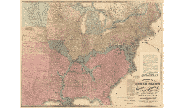
This map, created in 1864, shows the United States at war. It depicts Union states in yellow, Confederate states in red and Union-held Confederate territory (as of October 4, 1864). Cities highlighted in blue represent “Battle Fields, Strategic and Important places” in the South.
Note that the mapmaker considers large chunks of Missouri, Kentucky and West Virginia (slave-holding states that remained in the Union) as Confederate holdings. Indeed, many people in these states were sympathetic to the Southern cause. Citizens formed militias and fought alongside the Confederacy, and lawmakers from Kentucky and Missouri formed pro-Confederate governments. (The formal governments remained loyal to the Union.)
You can also see here a snapshot of each side’s progress in the war. Despite not holding much Confederate territory, the Union achieved key strategic footholds that sealed the South’s fate. Without access to the Mississippi River, the Gulf Coast and New Orleans, the South couldn’t as effectively maneuver its troops and supplies or trade with foreign nations.
The map also hints at the war’s horrors. A blue blotch marks Andersonville, Georgia, where thousands of Union soldiers were held. According to the map’s legend, the South held the prisoners “in an open field without shelter of any kind,” dying by the hundred each day.
Several organizations hold digitized Civil War maps of different battles, time periods and places. The David Rumsey Map Collection (which hosts this map) boasts more than 30,000 historical documents, and the Library of Congress has a collection dedicated to Civil War maps. The Civil War Trust contains a database of Civil War maps, including a narrated “animated map” that documents the war’s history.