Sign up for the Family Tree Newsletter! Plus, you’ll receive our 10 Essential Genealogy Research Forms PDF as a special thank you.
Get Your Free Genealogy Forms
"*" indicates required fields
00:00:00
The David Rumsey Map Collection is a free online portal that will help you put your family history on the map. Well, on lots of maps potentially!
00:00:09
Hi, I’m Sunny Morton with Family Tree Magazine here with a quick tour of this fantastic resource.
00:00:16
The David Rumsey Map Collection, housed at Stanford University Library, has 150,000 maps. More than 75% of them are now online at DavidRumsey.com.
00:00:28
While its scope is global, the collection is especially strong for maps of the United States and it’s free for everyone [to explore].
00:00:39
All kinds of maps can help genealogists find where their ancestors lived and what it was like.
00:00:44
Their property maps may show property boundaries, land use and landowners’ names.
00:00:50
Insurance maps go into much greater detail about neighborhoods, roads and buildings.
00:00:56
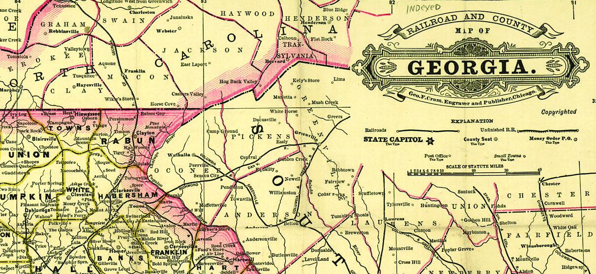
Railroad maps can help you research migration routes and communities that grew up along a rail line.
00:01:02
There may be military maps for understanding conflicts that affected your ancestors’ topographical maps for learning about the terrain and a variety of other maps that use historical statistics to describe the people living there, such as how many there were or their ethnicity.
00:01:21
I’m going to introduce you to some “get started spots” for the genealogist: the Luna Viewer, the Geo Referencer and the Google Earth browser.
00:01:30
Here at DavidRumsey.com, start your search in the main search box.
00:01:37
Let’s say you want to see maps showing settlement of Kansas during the 1870s, specifically Leavenworth County. Enter Leavenworth and Kansas as keywords.
00:01:47
Hit “Go.” A quick note on your searching if you’re used to doing more advanced searches on your favorite web browser: Good news, you can use terms like AND or OR equals to make your searches here more powerful.
00:02:00
Or you can put words or phrases and quotes to search that exact thing only, or use wild card characters to help with name or spelling variants (a question mark to replace one character and an asterisk to replace a string of characters).
00:02:17
Now let’s look at your list of search results. They’ll appear here in what’s called the Luna Viewer, a powerful interface for exploring these maps.
00:02:26
Before exploring them, you may want to customize your search experience, which you can do here under the Gear icon—you’ll see the option to choose the size and the number of how many appear on one page. And even to change the background color.
00:02:47
Now let’s look at what we’ve got.
00:02:49
The site makes it easy by letting you use these filters here along the left side to refine your search in several ways.
00:02:57
You can narrow down what type of resource you’re looking for.
00:03:01
You can choose associated or more specific locations.
00:03:05
I could click on Leavenworth County. And then [on] the more specific place name of Leavenworth or other places that include Leavenworth in some way.
00:03:15
Remember that the place you’re interested in may be under the name of various geographic jurisdictions.
00:03:22
Scrolling down, you can also search by specific map creators.
00:03:29
But one of the most useful filters for a genealogist is the time period. Clicking on 1878 allows me to look just at maps created that year. My search for 1878 brings up results that appear to be several pages from a digitized map book, which as you can see, includes all kinds of supporting pages that are not actually maps. But they can help you understand this place because that’s your goal when you’re searching for maps, right? To understand a place.
00:04:01
Let’s choose one of these map images. Now you can explore it in greater detail.
00:04:07
On the right, you can zoom in or out with these bars, look at the kind of detail that we’re seeing here show up. This is great.
00:04:20
It’s easy to get lost when you start really zooming in here.
00:04:23
Look, now you know that there’s a church there.
00:04:24
There’s a building there. Great details.
00:04:27
You’re along the river and there’s a little tributary.
00:04:30
So you might get lost in these pages, so you can use the left or right to move your way around.
00:04:36
Or if you just need to start over, you can also use the little home to go back to the original view.
00:04:43
You may want to rotate an image which you can do here, or you may want to fill your screen with the image right here. Again, you can make this larger or smaller, but this is also a great place to demonstrate the image manipulation toolbar.
00:05:03
So you can choose to rotate images either right or left.
00:05:07
You can change the brightness of the image.
00:05:12
You can adjust the contrast of an image.
00:05:17
You can even adjust the color saturation if you want more or less color. Or if you want to go black and white altogether, use the grayscale tip.
00:05:26
Sometimes it’s easier to read a map if you actually invert it just like this. And if you want to put everything back the way it was, use this reset button.
00:05:36
Now if you go up to the top here back to media, we’ll take you back into the main site.
00:05:42
You may find yourself wanting to come back to the David Rumsey Map Collection frequently, or create custom collections of your favorite maps and even create custom slideshows.
00:05:51
If so, you’ll want to register right here for free. Then you’ll navigate to the help tab into a series of Quick Start Guides to learn how to create and use a collection.
00:06:02
The Luna Users Guide will also be helpful if you become a more advanced user, which you can find under this help tab.
00:06:11
Now we’re going to check out the Georeferencer tool. When you click to view a map in Georeferencer, if the map has already been digitally overlaid on a modern map, you’ll see it here. This is a great way to confirm where that ancestral location is now.
00:06:26
Use the slider tool over here to make the map more opaque or transparent.
00:06:32
There are some more advanced tools here, including an overlay tool that lets you overlay multiple maps.
00:06:40
At any time, to get back to the home page, you can click on the David Rumsey Map Collection icon here, which I’m going to do because if you like this idea of overlaying old maps onto modern satellite imagery, you’ll love the Google Earth or Google Maps portals to explore all the maps from the David Rumsey collection that have been overlaid onto Google Earth.
00:07:03
If you Scroll down, you’ll see a variety of options for accessing them, depending on your preferences. This is super cool.
00:07:11
There are copyright restrictions you’ll need to consider if you want to share maps you find online. Learn more about these under the copyright and permissions section of the About.
00:07:22
If you’re a map [lover] or if this site turns you into one, you’ll want to check out the physical home of the David Rumsey Map Collection.
00:07:31
A visit to the Stanford libraries to see this is on my bucket list. Meanwhile though, I’ll just have to keep exploring the maps here at David Rumsey.
00:07:42
I’m Sunny Morton for Family Tree Magazine.Thanks for watching.
Related Reads