Sign up for the Family Tree Newsletter Plus, you’ll receive our 10 Essential Genealogy Research Forms PDF as a special thank you!
Get Your Free Genealogy Forms
"*" indicates required fields

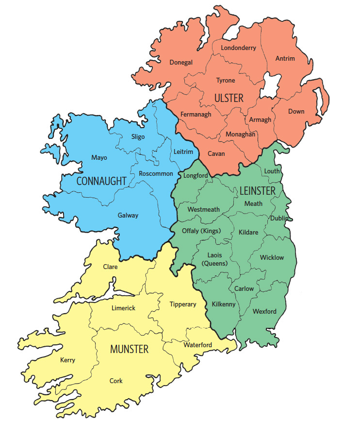
If you have Irish roots, you’ve probably at least heard of the counties in Ireland. Consult this map of Ireland and its counties to figure out which your ancestor lived in.
The county served as the most general administrative unit for much of Irish history. The government divided counties into baronies, then civil parishes, then townlands. The townland is likely the most important in finding records, but knowing which county your ancestor hailed from is still a good starting point since you’ll likely find record groups sorted by county. Other significant administrative units include poor law unions, which were used in civil registration.
Counties of Ireland and their provinces
The 32 traditional Irish counties form four provinces. Though the provinces have no modern official status, you may still find them mentioned throughout your research. In the Ireland map above, each color represents a province and the counties in it:
ADVERTISEMENT
- yellow for Munster
- blue for Connaught
- red for Ulster
- green for Leinster
Looking at a modern map of Ireland, you might notice the counties don’t all lie in the same country. Since 1922, the counties of Londonderry, Antrim, Down, Armagh, Tyrone and Fermanagh have made up Northern Ireland, a constituent part of the United Kingdom. The remaining 26 counties make up the independent Republic of Ireland.
The Irish and UK governments don’t necessarily use traditional county boundaries for administrative purposes today. In the Republic of Ireland, most counties still form the basis of local government for most purposes. But Northern Ireland initially used county boundaries for administrative purposes, but revised districts in 1972.
Related Reads
FamilyTreeMagazine.com is a participant in the an affiliate advertising program with Genealogical Publishing Company. It provides a means for this site to earn advertising fees, by advertising and linking to Genealogical.com.
ADVERTISEMENT
ADVERTISEMENT


