Go West in your ancestry with this overview of the Mexican Cession.
Background: The Mexican-American War
In 1821, Mexico secured its independence from Spain. At the time, its borders comprised former Spanish holdings in North America, which stretched north to the 42nd parallel, west to the Pacific, and east to the Nueces River.
Texan independence and annexation
But peace was short-lived. Settlers in the US-Mexico border region of Texas (who outnumbered Mexican citizens 10-to-1) ignited their own bid to become an independent republic. Early skirmishes included the famous siege of the Alamo mission near San Antonio, where Mexican forces under General Santa Ana overran Texan and American defenders (including frontiersman Davy Crockett).
“Remember the Alamo!” became a rallying cry for the Texan army raised by Sam Houston. Texas declared independence in 1836 and secured a treaty with Santa Ana; the Mexican government recognized neither the republic nor its claimed borders. The Lone Star Republic legalized slavery, and its residents voted to join the United States.
Texas annexation became a hotly debated topic among US politicians, but stalled throughout the late 1830s and early 1840s. It became just the latest front in the battle between abolitionists (who wanted to halt slavery’s westward expansion) and advocates of slavery (who saw westward expansion as essential to the Southern way of life). Though Mexico had outlawed slavery, many American settlers in Texas were enslavers. And many Southerners had come to Texas to aid in the fight against Mexico.
It was common understanding that annexing Texas would trigger a war with Mexico. Despite this, Texas joined the Union in 1 March 1845, just days before the inauguration of President James K. Polk. Mexico (which refused diplomatic envoys and had just undergone a nationalist government takeover) severed relations with the U.S.


A controversial war
Polk campaigned on territorial expansion to both the north and south, and was eager to jump on the tense situation with Mexico. He sent American troops to the border and successfully baited Mexican forces into attacking. The U.S. declared war on Mexico on 13 May 1846 under this pretext.
At the time, the war was subject of considerable controversy:
- Abraham Lincoln, then a freshman Congressman from Illinois, openly questioned the Polk administration’s account of the skirmish. His “Spot Resolutions” called on Congress to “establish whether the particular spot on which the blood of our citizens was so shed was or was not at that time our own soil.”
- Henry David Thoreau, while on his famous retreat to Walden Pond, was jailed for refusing to pay taxes in protest of slavery and what he felt was an unjust war. His influential essay “Civil Disobedience” was written partially in response.
- John Quincy Adams, former president, mused the war was a gambit by the South to find “bigger pens to cram with slaves.”
- Ulysses Grant, who rose to the rank of captain during the war, later considered it morally unjust—and the Civil War, divine punishment. “The wickedness was not in the way our soldiers conducted it, but in the conduct of our government in declaring war,” Grant told a journalist later in life. “I am always ashamed of my country when I think of that invasion.”
Grant’s connection between the two wars was apt in another way. Many future Civil War figures (for both the Union and Confederacy) fought in the Mexican-American War: P.G.T. Beauregard, Braxton Bragg, Jefferson Davis, Joseph Hooker, Thomas “Stonewall” Jackson, George B. McClellan, George Meade, and the previously mentioned Ulysses Grant. This gave officers who would later be on opposing sides familiarity with each other, in addition to combat experience.
A lopsided peace: the Treaty of Guadeloupe Hidalgo
The U.S. decisively secured victory, driving Mexican forces first out of California, then New Mexico. Forces under General Winfield Scott then captured the capital of Mexico City. That put the Union in a strong negotiating position.
The result was the 1848 Treaty of Guadeloupe Hidalgo, in which the U.S. acquired 338 million acres of Mexican land in exchange for $15 million ($568 million in 2025). The fee was a paltry sum given the amount of land and how valuable it would become.
Aftermath
The Mexican Cession partially sated the rabid desire of Americans for westward expansion, fulfilling the domestic goal of “manifest destiny.” The United States now had land claims from the Atlantic to Pacific.
But the war and treaty had long-lasting consequences beyond the transfer of land:
- Slavery: Like Texas, the newly acquired territories deepened sectional conflict as free and slave states both vied for influence out West. The Compromise of 1850 admitted the populous California as a free state and allowed the new territories of Utah and New Mexico “popular sovereignty” to determine whether slavery would be permitted. The peace wouldn’t hold, however; Texas seceded from the Union in 1861, and the Confederacy held claims to what is now Arizona and New Mexico.
- Railroads: Developers were eager to connect the East with the newly acquired West, especially the goldmines of California and (later) silver mines of Nevada. The Gadsden Purchase (1853) added another nearly 30,000 square miles of formerly Mexican land to Arizona and New Mexico to facilitate a transcontinental railroad.
- Diversity and discrimination: Per the treaty, Mexicans living in the transferred territory were to become US citizens if they so chose. However, their rights often went unrecognized. Speaking a different language (and many of them Catholic), Mexican-Americans faced discrimination, even in places where they held a majority.
States and Territories of the Mexican Cession
Comprising 530,000 square miles, the Mexican Cession was the third-largest land acquisition in US history, behind only the Louisiana Purchase and “Seward’s Folly” (the 186X purchase of Alaska).
The land surrendered by Mexico (and annexed as part of the Republic of Texas) made up all or part of 10 future states:
- Arizona
- California
- Colorado (western and southern)
- Kansas (southwest corner)
- Nevada
- New Mexico
- Oklahoma (panhandle)
- Texas
- Utah
- Wyoming (southwest)
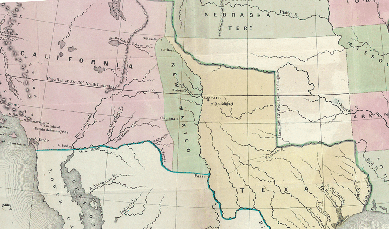
The land was initially divided into three sections: a vast California territory, the state of Texas, and the New Mexico Territory between them. After California was admitted as a state in 1850 (see above), Congress adjusted Texas’ borders and created separate Utah and New Mexico Territories.
Genealogy and the Mexican Cession: What to Know
If your ancestors lived on formerly Mexican land (or through the Mexican-American War in general), here are some topics to consider.
Military records
More than 100,000 soldiers served in the U.S. Army during the Mexican-American War. Their actions are documented in compiled military service records (CMSRs) held by the National Archives, which also has educational materials about the conflict. And volunteers from the former Federation of Genealogical Societies collaborated on a database of Mexican-American War veterans.

Jealous of genealogists with ancestors in major, record-generating US wars? Don’t be. We’ll help you trace people who served in 10 lesser-known military conflicts.
Migration
Easterners sought their fortunes in new communities out west. California, in particular, became a hotbed of migration after gold was discovered at Sutter’s Mill in 1848. Settlers followed migration routes through the region like the Santa Fe Trail and Old Spanish Trail.
Settlement was uneven, however. Early communities sprung up around mining ventures, then disbursed when mines went drive. And the Southwest’s arid climate made travel and settlement difficult. As a result, Arizona and New Mexico (admitted in 1912) were the last in the contiguous U.S. to join the Union. They were also the last states to begin keeping vital records.
Public land and homesteading
Land in all the Mexican Cession (except for modern Texas) was surveyed using the Rectangular Survey System. That means the federal government itself sold land to interested parties. Notably, the Homestead Acts of 1862 offered new criteria for settlers willing to move to frontier regions and improve the land there.
A version of this article was posted online in February 2026.
Related Reads